
Is it time to ditch the phrase "Road Diet"?
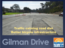
A four-lane road, Gilman Drive in La Jolla near the Univ. of California San Diego (UCSD), recently had new sewer lines installed. A stretch of this newly-repaved road was three weeks away from getting re-striped when BikeSD mobilized to have the speed limit reduced and buffered bike lanes added.
BikeSD had tentative support for this change of striping from staff at UCSD. But after BikeSD's executive director presented plans for a road diet to the local community advisory group, UCSD was upset. They felt BikeSD had pulled a fast one on them by switching from a “re-striping” to a “road diet.” They weren't sure they could or would support a "road diet" on Gilman Drive.
UCSD's reaction isn't surprising to road safety advocates. Very often, when average people — car drivers — hear the phrase "road diet," they have negative reactions. The word "diet" means reducing and restricting. A traditional diet may reduce carbs; a road diet reduces cars. A traditional diet may squeeze down your waistline; a road diet squeezes the room around your car.
While notions like reducing cars and squeezing the roadway appeal to bike and safety advocates, these phrases have no positive connotation to people on a community boards, traffic engineers, or average folks who depend on driving. Simply put: when advocates use the phrase "road diet" we conjure up the wrong imagery in the ears of our listeners.
On top of that, everyone knows: "Diets don't work."
So maybe it's time to ditch the phrase "road diet." And time to ditch the phrase "traffic calming" as well. ("Traffic calming" sounds like a plan to have drivers just settle in and wait out the slow snarl of traffic while meditating. No driver wants to hear about how a street design will slow down, calm, or involve "traffic.")
It's time to adopt better phrasing for this important work.
I'd like to propose a new framework and term: M.O.S.T.
Mobility-
Oriented
Safety
Treatment
We all want to get the MOST out of our roadways.
Just about every element of a road diet is also a treatment to expand the use and users of a road. A roundabout reduces the need for stop signs, allowing better flow through intersections for both cars and bicycles. Buffered mid-speed lanes (aka bike lanes) increase the capacity of a street by accommodating bikes, scooters, and congestion-reducing methods of getting down the street. Bulbouts and curb ramps make traveling on foot or by wheelchair more pleasant and safe, thereby increasing the likelihood for walking (fewer cars), reducing the need for paratransit vehicles (fewer vans), shortening pedestrian crossing times for people at intersections, etc.
Almost every road diet element is also safety-enhancing step. The problem is that the phrase "road diet" fails to capture any notion of increasing safety. 'Diet' inherently sounds like less rather than more. In reality, we're talking about enhancements, not reductions.
MOST is about getting the most out of our road space. MOST street design focuses on maximizing the number of ways people can use a street. Roads which get the MOST design are safer than traditional road layouts. More importantly, a MOST street serves the greatest amount of people -- not just one type of user (typically cars). When we pitch to audiences about bringing the MOST to a street design, we're talking about expanding the road to its greatest, safest capacity.
MOST, as a phrase and a framework, reminds everyone (car drivers, walkers, folks, bikers, scooter users, the disabled, parents with strollers...) that we share a common goal: getting the most value from our shared street space. Who wouldn't want the MOST for their roads?
SANDAG Monroe Bikeway Held Hostage by Kensington Talmadge Planning Group, Residents
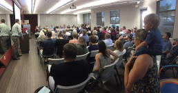
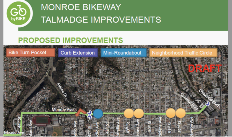
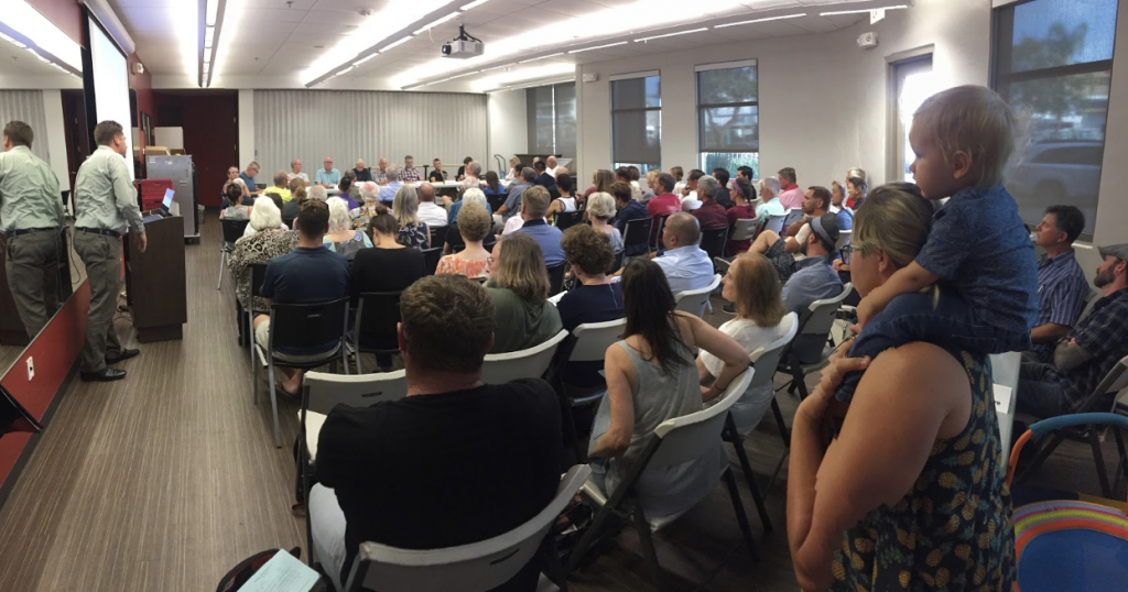
Last week the Kensinton Talamadge Planning Group (Ken-Tal) received an update on the Monroe Bikeway segment of the North Park-Mid City Bikeways from SANDAG (San Diego Association of Governments) staff member Danny Veeh. The Monroe Bikeway is one of the last planned segments of the still-unconstructed North Park Mid City bikeways, and is a 1.3 mile bicycle boulevard connecting from Copley Price YMCA to Collwood Blvd in the College Area:
Before summarizing the events of the meeting (hint: it didn’t go well), let’s go over the history of bike lane projects in the Talmadge area:
- October 2013: SANDAG OK’s $200M in early action funding to the bike lane network
- 2014: SANDAG awards City of San Diego with a Complete the (El Cajon) Boulevard study grant, to make the Talmadge section of ECB a “vibrant, safe, pedestrian, bicycle and transit-friendly area”
- July 2015: (Former) Ken-Tal chair David Moty calls on City, SANDAG to make Monroe Bikeway “the earliest part of SANDAG’s Early Action Plan”
- June 2016: SANDAG staff present Monroe Bikeway to Ken-Tal
- September 2016: Ken-Tal unanimously votes against bike lanes on El Cajon Boulevard as part of the Complete the Boulevard study, because of Monroe Bikeway:
- January 2017: San Diego selects Ken-Tal’s bike-unfriendly, watered-down redesign of El Cajon Boulevard
- July 2017: SANDAG staff present Monroe Bikeway modifications to Ken-Tal
- July 2018: SANDAG staff present more Monroe Bikeway modifications to Ken-Tal, including removal of HAWK signal at Aldine at the request of Talmadge residents
So after multiple years of Monroe Bikeway planning, traffic studies, traffic modeling, presentations to planning groups/planning group subcommittees/maintenance assessment districts/community councils, modifications to those presentations, more modifications to those presentations, and votes against other bikeways because of Monroe Bikeway—what did Ken-Tal planning group do? They prepared to vote against the Monroe Bikeway.
The overriding issue that long predates this project is auto congestion on Monroe during rush hour. While Ken-Tal and the City have implemented many attempts to address this issue, the entire community has never been satisfied. The city tried stop signs in 2013, left turn restrictions from 47th to Monroe in 2015, and Ken-Tal floated closing 47th at Monroe and a traffic island that restricted turns. Ken-Tal has also voted to widen El Cajon Boulevard at Fairmont, directly contradicting the city’s safety efforts on this deadly street for pedestrians. These actions have exposed a bitter community divide over a basic equity issue: Should auto access to one of the most heavily-used two-lane roads in the city be limited to wealthier north Talmadge residents, or do lower income residents in south Talmadge and City Heights have a right to this public road too? The City of San Diego answered this question by instructing SANDAG to design the bikeway without altering access to Monroe from 47th.
Despite Ken-Tal chair Don Taylor’s reminders that congestion issues are well beyond the scope and budget of the bikeway, Talmadge residents and board members continue to hold the Monroe Bikeway project hostage over this neighborhood dispute. In 2017, SANDAG staff was prepared to move the project forward for environmental clearance but delayed the project for 1 year to appease Ken-Tal’s concerns. As Ken-Tal requested, a HAWK beacon was replaced with a bicycle only left turn pocket in the most recent design. Despite this concession, many board members still refused to support the project. Remarkably, former Ken-Tal chair David Moty removed his support as a result of this concession.
When community members oppose a project for reasons that directly contradict each other, how is SANDAG ever expected to achieve the elusive “consensus” required for bike lane projects that is not required for freeway widenings and road expansions? This is the main reason why nearly every SANDAG bike lane project is behind schedule: attempting to appease armchair engineer residents who write 62-page manifestos demanding the city subsidize his lack of off-street parking, or Ken-Tal board members who attack the Monroe Bikeway for failing to improve safety—while offering no viable alternative. A Talmadge attorney even insisted the California Environmental Quality Act prohibits the bike lane—despite the governor signing two laws that prevent this environmental policy from being perverted to kill bike lanes.
Meanwhile, here’s fomer Ken-Tal chair Moty in 2015, offering full support for the Monroe Bikeway: “SANDAG staff are faced with challenges enough elsewhere, we should not create challenges for them here where overall community support is strong. The KTPG does not believe this is the city’s intent, and hopes the city will give its full support to SANDAG’s plan and remove any roadblocks to its implementation.”
As Ken-Tal prepared to vote “no” on the Bikeway (with chair Taylor, Transportation Subcommittee chair Sean Harrison and Deborah Sharpe the only apparent “yes” votes), District 9 City Councilmember Georgette Gomez asked the board to postpone their vote. Gomez was present for the full 2 hours of contentious debate about the Bikeway and does not support 24-hour left turn restrictions onto Aldine from Monroe. She promised to take the feedback from the community planned to work with SANDAG and City of San Diego staff. Councilmember Gomez has been vocal supporter of active transportation in her role on SANDAG’s Transportation Committee and BikeSD is hopeful her leadership will result in a high-quality Monroe Bikeway.
Yet so far Ken-Tal’s efforts to delay the Monroe Bikeway have been successful. As we’ve seen with the Uptown Bikeway and in communities across the country, this is a proven model to continually delay and water down bike lanes, until eventually killing them. If San Diego is going to implement any of SANDAG’s bicycle projects, city leaders must not give into “advisory” planning groups, who actually hold a powerful veto over bike infrastructure. Further, Ken-Tal’s long history of placing its own interests over the larger Mid-City community (attempting to move planned retail away from El Cajon Boulevard; voting to worsen pedestrian safety on ECB) is another reason why planning groups should be consolidated—at a minimum.
For supporters of the bikeway, the next big timeline will be a CEQA exemption hearing. Prior to the recent Ken-Tal planning meeting, SANDAG planned for a September hearing. Any delay will add to concerning pattern of City of San Diego and SANDAG tolerating delays to SANDAG’s early action bicycle plan.
Bike Infrastructure Explained: Bike Box

This post is the first in a series of posts that will explain and illustrate bicycle infrastructure designs. These are the designs we want to see on our streets. These are designs that provide solutions for rider safety and comfort. All of the infrastructure featured is from the NACTO Urban Bikeway Design Guide which “is based on the experience of the best cycling cities in the world.” And here at BikeSD we want San Diego to be one of the best cycling cities in the world! So let’s start with BIKE BOX.
What is a bike box? If you google bike box, you will see a shipping box, but that is not what we are talking about. A bike box is a designated area (generally painted green) at the head of a traffic lane at a signalized intersection (an intersection with a stop light or traffic light.) It provides bicyclists with a safe and visible way to get ahead of a line of traffic during the red signal phase (when the light is red.) Nearly all the benefits of a bike box are related to increased safety for riders. But, there are some benefits to motorized vehicles that come from using bike boxes.
Bike Box Benefits
A bike box increases VISIBILITY of people riding bicycles. There are things that riders do to make themselves visible such as wearing bright clothing and using flashing lights. Being visible is key to bicycling safety. A bike box on the street helps bicycles be more visible at intersections. The bright green painted box highlights a location and motorists can expect to see someone on a bicycle in that location.
A bike box decreases the chance of a RIGHT HOOK which is a leading cause of both car vs bicycle and car vs pedestrian crashes. A right hook dangerous crash that involves a vehicle turning right into the path of a pedestrian or a bicycle going straight. Bike boxes can help prevent this kind of crash because the bicycle rider is positioned at the front of motor vehicles at the intersection.
A bike box provides PRIORITY for bicyclists at signalized intersections of major streets. Groups of bicyclists together can clear an intersection quickly, minimizing impediment to transit or other traffic. This priority has benefits for motorized vehicles because the people on bicycles in the bike box clear the intersection more quickly than a line of bicycles so right turning traffic moves through the intersection more quickly.
Bike Boxes in San Diego
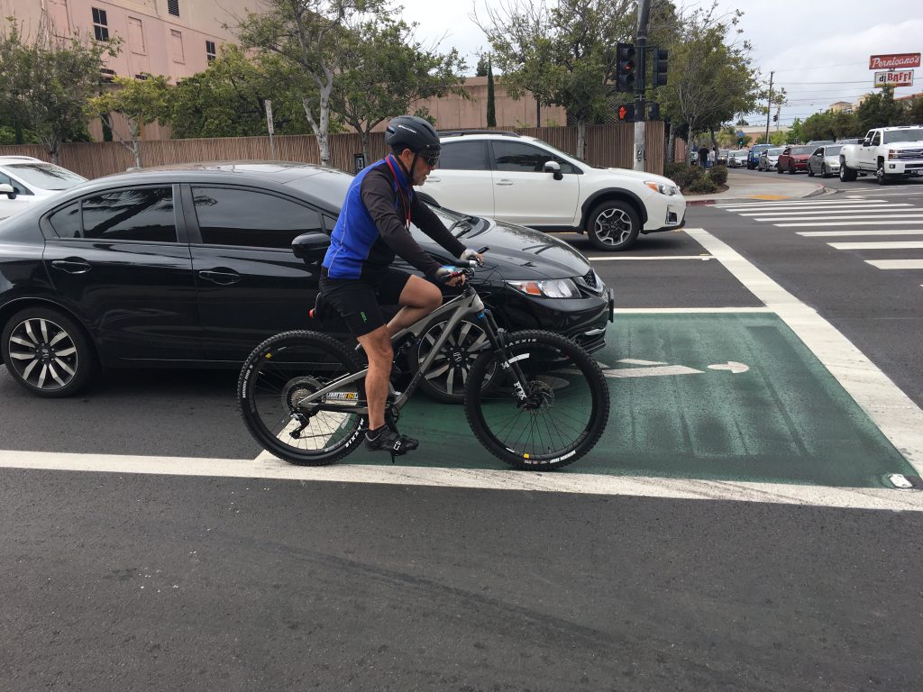
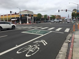
The intersection of University Ave and 6th Ave in Hillcrest has a bike box as part of the recently painted bike lanes. Cars are supposed to stop at the edge of the box, but have not yet learned how to use the infrastructure. Some bike boxes have WAIT HERE painted at the limit line of the box.
The new infrastructure on University Ave helps with comfort and safety. It is not perfect, but it is a start.
Balboa Station Plan: Does it solve the mobility issues around Balboa Ave station?
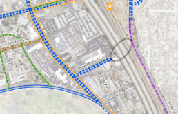
As anyone that has ridden along the Rose Canyon Bike Path or in the UTC area knows, SANDAG is in the process of extending the Mid-Coast Trolley from Old Town to UCSD and UTC area. The potential of this $2.1 billion investment can only fully be realized by enhancing the accessibility of the stations to surrounding neighborhoods. The City of San Diego is currently drafting a planning document for the area around the Balboa Avenue Station. Eventually, the plan will be voted on by San Diego’s City Council. (The current draft plan is can be read here and the image below shows the area being included in the plan.)
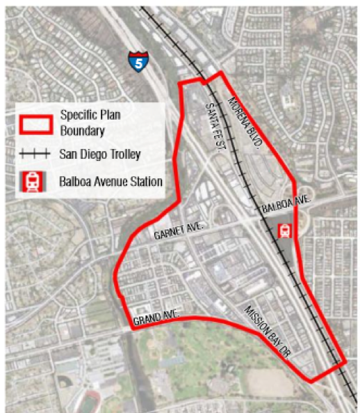
Currently, the area depends on a very autocentric roadway design. The proximity of Interstate 5 and on-ramps and off-ramps into the area bring high speed traffic directly into the plan area. The northbound I-5 exit onto Mission Bay Drive encourages drivers to maintain freeway speeds into Pacific Beach. Despite high volume of bicycle traffic, Mission Bay Drive has no bicycle lanes. Rose Creek Bicycle Path is an alternative to this high speed road but the utility of this path is constrained by a narrow path, lack of lighting and frequent homeless encampments. Despite most businesses in the area having large parking lots, Mission Bay Drive allows free street parking. Traveling east of mission bay drive on Balboa Avenue, cyclists contend with high speed traffic, high speed interchanges with Morena Boulevard and an uphill climb into the Clairemont neighborhood. In short, the current conditions need improvement and are a barrier to area residents trying to access Mission Bay, the beach areas, and generally traversing the intersection of Balboa Avenue and I-5 / Morena Boulevard.
While the draft Balboa station does not fix all of these issues, it does attempt to make improvements.
For non-bicycle specific infrastructure, the plan supports the elimination of free rights and other high speed conditions in the below examples.
- Removal of freeway style ramp eastbound Balboa Ave to Morena Blvd ramp
- Changing an I-5 off ramp onto Balboa Ave to a signalized (albeit widened) off ramp
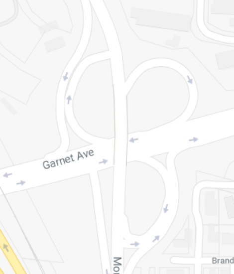
- Add a a traffic signal at westbound Balboa Ave & Morena ramps and remove free right turn ramps
Recommended Bicycle specific infrastructure
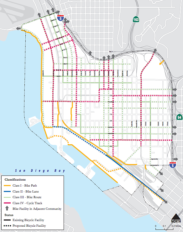
- Enhance Rose Creek Path
- Class II bike lanes on Mission Bay Drive
- Class II bike lanes from Santa Fe st to Moraga St (width permitting)
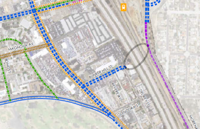
- Class II bike lanes on Bunker Hill road
- Class III (Sharrows) on Garnet from Mt Soledad Road to Santa Fe Street
- Class IV (cycletrack) on Santa Fe Street (Purpose of this cycletrack appears to allow cyclists to access Rose Canyon and points north since Santa Fe is recommended to be southbound only in the plan)
- Class IV (cycletrack) Morena Blvd (west side) from Gesner to Balboa Station
Overall, the plan recommends a lot of improvements that will help bicyclists. As a frequent commuter through the area, I am excited about the bike lanes on Mission Bay Drive. The current state requires a bicyclist to control the lane with honking, hostile motorists. Removing some automobile parking for a bike lane is needed to create high quality, safe bike lane.
So for the bicyclist commuting north/south through the area, this plan provides improvements. However, it does not appear that this plan does anything to slow freeway traffic from I-5 as it exits from I-5 northbound. This should be corrected as it is a major hazard.
Biking to and through the plan area from Pacific Beach will remain a challenge. Grand and Garnet Avenues are the only roads that travel over Rose Creek. In the draft plan, sharrows (class III) are recommended on Garnet to reach the station area. The Pacific Beach Planning Group is not happy with that recommendation. The PB planning group calls the recommended sharrows “unacceptable.”
A pedestrian/bicyclist bridge crossing I-5 from Bunker Hill St is proposed in the plan. This would provide a stress-free route for bicyclists to access the trolley station. The PB planning group asked for the plan to include the pedestrian/bicycle bridge over I-5 in the earliest phase. However, a funding source and commitment needs to identified. Since it helps the City of San Diego reach both Climate Action Plan goals and maximize the investment in the expanded trolley, this project should be a high priority for the city.
The city is still looking for feedback on its plan. Please ask the city to prioritize safe bicycle routes (including the I-5 bridge!) in the plan. Provide feedback to city of San Diego planning department, Michael Prinz, Senior Planner, Planning Department, Mprinz@sandiego.gov. Another option to give feedback is the city provided website. As you probably suspect, not everyone wants bicycles accommodated. Don’t allow the below comment represent your views and dilute the potential great improvements that could be implemented.
![]()

2018: Hopefully a year of progress for bicyclists
In 2018, San Diego needs to take another step forward towards becoming a world class bicycling city. While the streets of San Diego have become increasingly bike-friendly, San Diego needs more than incremental changes to meet our safety and climate action goals. Below are a few of the initiatives we will be watching for improvements. If you have other suggestions, please contact us through email (talk@bikesd.org) or twitter (@bikesd).

Downtown Mobility Plan
The plan to redesign our auto-centric downtown area was approved in June 2016, but what city council passed was primarily a planning document. Will the final design reflect the world-class, high quality bikeway design that downtown deserves? City staff needs to resist the temptation to accommodate NIMBY street parking concerns that would compromise the bikeway quality and residents’ safety. We hope city staff will continue to work with bicycle advocates to ensure success.
SANDAG Early Action Programs
SANDAG approved 40 early projects throughout the county in 2013. The stated goal was for projects to be completed within 10 years. As KPBS recently highlighted, SANDAG has consistently postponed project timelines. If new bikeways can be installed in Manhattan in just one year, why do they take several times that in San Diego? In 2018, we will hopefully celebrate the groundbreaking for 1st segments of Uptown Bikeway and North Park-Mid City bikeways.
Resurfacing & Repurpose
As the Mayor office fulfills his pledge to resurface streets, any street on the city’s bicycle plan should accommodate the facility specified in master plan. While efficient, this resurface/repurpose effort does not allow for a large network of bicycle infrastructure to be built. Also, road diets and the removal of parking require community approval beforehand. The city should remove this unnecessary layer of approval to implement its bicycle master plan and climate action plan (both approved unanimously by city council). While this layer of community approval is unnecessary, it reinforces the need for BikeSD supporters to join your local community planning group.
Community Plan Updates
Every community plan update has a mobility element. Many of San Diego community plans are outdated. BikeSD supporters should advocate for safe bicycling facilities in all community plans. If a bicycle facility is on an approved community plan, it will be easier to advocate for it in the future. Currently the city is working on Barrio Logan, Midway, Old Town, Kearny Mesa, Clairemont, and Mission Valley community plans. (Please let us know if we missed any!!!)
Bicycle Advisory Committee Strategic Implementation Plan
For the past couple of years, a group of appointed volunteers has worked with city staff on implementing the city’s bicycle master plan. As KPBS reported, the plan was delayed after bicycle advocates voiced concerns. City Council should approve an implementation plan that satisfies the advisory committees concerns. (As an aside, the bicycle advisory committee currently has opens positions, interested BikeSD supporters should contact their respective council district offices if interested in joining.)
Parking
We don’t believe the storage of private property on public streets is the best use of our precious space. As of start of 2018, the city has not allowed any bicycle infrastructure that even removed 1 parking spot—even when abundant off-street parking exists. This needs to change! In fact, the city needs to implement a parking management strategy that is more than “more!!” Start with Donald Shoup’s ideas.
Don't forget to attend our next Bike San Diego Meetup!
When: March 6 at 6pm
Where: Iron Pig Alehouse (Pacific Beach)
We'll be meeting on March 6 in Pacific Beach at Iron Pig Alehouse for an evening of community, conversation, and discussion of Community Planning Groups. Circulate San Diego will be joining BikeSD to discuss how residents can (and should) get involved in local planning groups to help create a world-class city for biking. Doors open at 6, we'll have a presentation and panel discussion at 7, which will be followed up by a social hour.
RSVP