
Georgia-Meade Bikeway
Some thoughts and next steps
Description
The Georgia-Meade Bikeway is a 3.5 mile segment of the greater North Park | Mid-City Bikeways, which is a 13 mile network of bike corridors that connect the Mid-City neighborhoods north of Balboa Park to Downtown. Meade runs horizontally from Kensington in the east to University Heights in the west, at which point the bikeway extends south via Georgia into North Park.
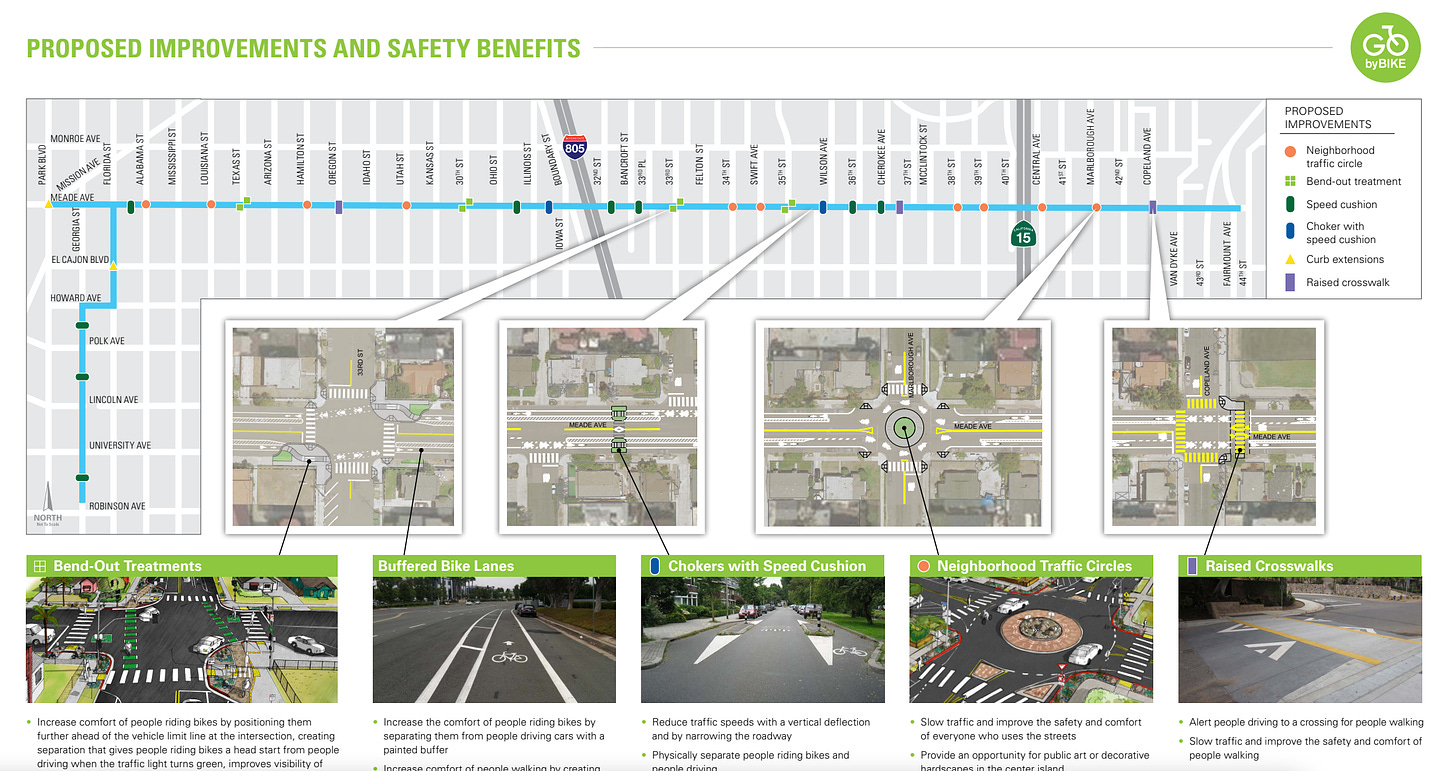
On the ground, Meade Avenue has been given a dramatic road diet, whereby roads have been narrowed to allow for Class II bike lanes. Though some might’ve preferred Class IV bikeways, the combination of Class II and punctuated traffic calming measures (roundabouts, raised crosswalks, and chokers) on this lower traffic volume road (compared to El Cajon Blvd., Madison Avenue, or Adams Avenue) should be sufficient. The improved road elements are meant to decrease the likelihood of a head on collision, reduce traffic speeds, and make active transportation both on and off the road a more comfortable experience.

Benefits
The Mid-City neighborhood consists of over 130,000 residents spread out across some of the most densely populated communities in San Diego. On top of the population density, Mid-City also contains some of the most mixed-used communities in the city. This fusion of residential, commercial, and recreation makes Mid-City a great place to implement more pedestrian/bicycle oriented design. The Meade-Georgia Bikeway, allows residents from the more residential neighborhoods of east Mid-City to easily access the business districts scattered across the western portion (e.g. North Park via 30th Street, Adams via 35th, Normal Heights via 33rd, University Heights via Park Blvd., and the entire strip of businesses along the parallel boulevard, El Cajon).
By inducing greater demand across this east-west corridor, the Mid-City community can reduce vehicular traffic through these denser, pre-war neighborhoods. Most significantly, this greatly decreases the probability of vehicle-pedestrian collisions. Other potential benefits include reduced traffic congestion for those that absolutely must drive and decrease demand for parking in the various business districts (a popular point of contention when discussing non-car infrastructure). Some potential long term benefits are an improvement in air quality for residents living on or near the corridor, improved transit efficiency, and longer pavement lifecycles.
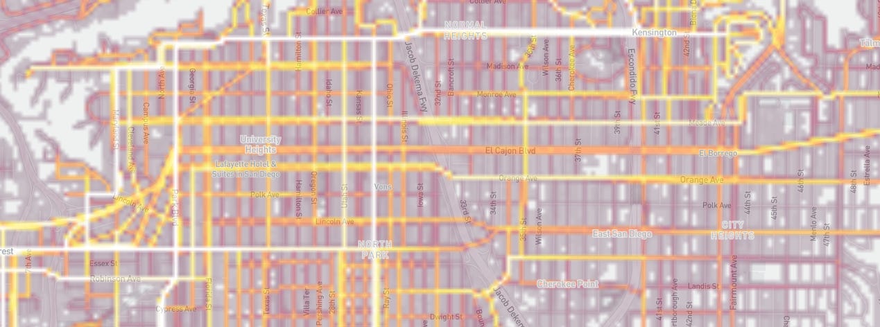
Though the city has not implemented any bike counters on this route, preliminary heatmap data from both Strava and Ride With GPS show promising bicycling activity along the Meade-Georgia Bikeway.

Feedback
I live in Kensington and use Meade almost every single day. Most mornings, I use it to get to the gym in University Heights. During the day, I use it to visit stores and businesses on 30th, Adams, or El Cajon to grab food and run errands. It’s even comfortable to ride along in the evening (if a little dark), on days where I’m coming back from seeing friends in Hillcrest, University Heights, or North Park. I love seeing fellow bicyclists ride past, residents walking their dogs, homeowners tending to their yard, and businesses opening up for the day as I commute between the small neighborhoods sprinkled across Mid-City.
The segment between Marlborough and Georgia is generally fine though there are a couple of things that can be improved.
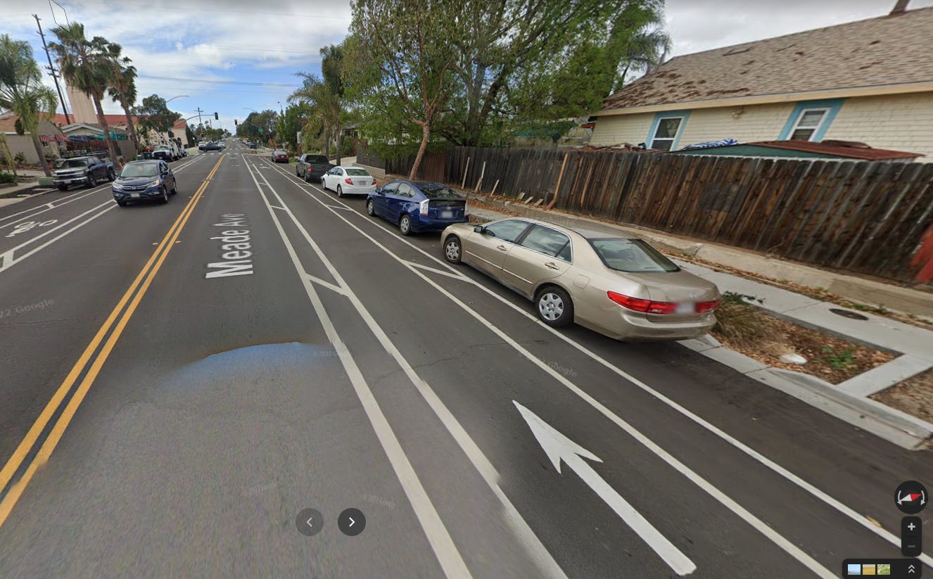
- There are 10 roundabouts (or, traffic circles) scattered throughout Meade Avenue. Roundabouts are great: they slow down traffic, reduce head-on and side impact collision frequency and severity, and allow for decorative landscapes on what would otherwise be a patch of grey concrete. However, the striping pattern upon entry can lead to some confusion. In the picture below, you’ll notice that the bike lane abruptly ends and forces a quick merge into the sharrow right before entering the roundabout.
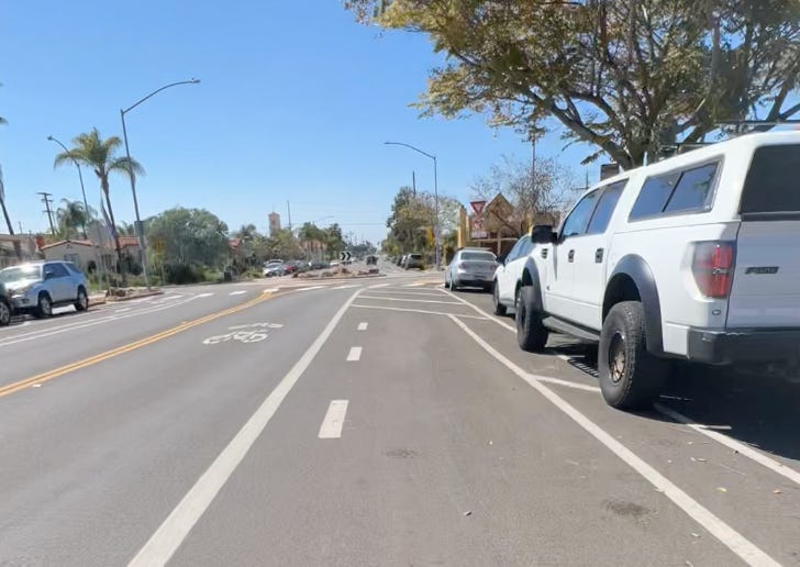 Generally, this maneuver can be done thoughtlessly, thanks to the relatively low volume of traffic present at any time. Nonetheless, I think more clear striping would go a long way in making Meade Avenue truly for all ages and abilities.Other cities have solved this problem by using colored (usually green) pavement and way-finding signals. In the case of the above roundabout entrance, I’d like to see the bike path curve into the traffic lane using green (or red, to follow the Dutch) paint and clearer way-finding.Here are a couple of examples from Austin and Salt Lake City(below) has done a great job of demarcating bike paths through wide intersections and sudden chokepoints.Austin, TX uses white stripes and sharrow markings to demarcate the recommended travel path for bicyclists across a wide intersection (nacto.org)An abrupt choke point in Salt Lake City, UT is clearly demarcated with a green lane and sharrow markings (nacto.org)
 - Meade Avenue intersects with 30th Avenue, another bikeway that was recently opened. Despite both of these individual bikeways being terrific places to ride, the junction between them feels more like an afterthought. In the picture below, I’m facing west on Meade with the intent of turning left onto 30th. To do so, I need to wait at this intersection, yield to oncoming traffic (because this is an unprotected left turn), and then turn through the intersection. Again, not a deal breaker, but an element that can certainly be improved upon, especially if we’re wanting to encourage people of all ages and abilities.
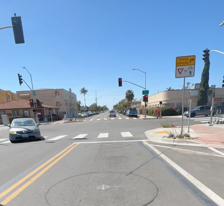 The typical strategy here would be to add a bike box to the right side of the intersection on 30th, so a bicyclist would position herself there when Meade Avenue is green and then continue south when 30th turns green. I think that requires too much waiting for what isn’t a terribly busy intersection. A more simple change would be to allow for a leading left turn signal which would benefit both left-turning bicyclists and vehicles. Obviously, the pedestrian crosswalk signal would defer to left turning vehicles.
These issues are not specific to the Georgia-Meade bikeway – similar bicycle connectivity issues can be found throughout San Diego (in that interactive map, a lot of the blue and green lanes are extremely uncomfortable for bicyclists, e.g. El Cajon Blvd ).
Indeed, many of the existing bikeways may be great for commuting but fall short when trip chaining ( journeys that consist of numerous shorter trips) is required. As a remnant of mid-century modern urban planning, many bicycle corridors are focused on commuters, that is, getting riders from point A to point B, while not providing the necessary connectivity to comfortably access everything in between.
Next steps
San Diego’s bicycling network and culture are in its early stages: in 2018 the city was awarded Bronze status by The League of American Bicyclists, with one of the recommendations to achieve Silver status being:
Continue to expand the bike network and increase connectivity through the use of different types of bicycle facilities appropriate for the speed and volume of motor vehicle traffic on each road
It is encouraging that our current mayor, city council, and regional government (SANDAG) continue to push for more robust bicycle and pedestrian infrastructure. In the 2021 Regional Plan, there are dozens of projects dedicated to Active Transportation, one of the main categories of focus (Appendix A: Transportation Projects, Programs, and Phasing, Page 6), with $292 million allocated to regional bikeway projects. San Diego City is allocating $28.1 million towards their Vision Zero initiative, including $11.9 million for bicycle facilities (Adopted Budget Fiscal Year 2022, Volume 1: City Budget Overview, Page 19).
In fact, the city recently announced that Park Boulevard would receive protected bike lanes between Adams Avenue and University Avenue. This is a great extension of the existing east-west bikeways (including Georgia-Meade) that cut through Mid-City, allowing easy access to the many businesses and residences that line Park Blvd.
The next step is ensuring that the Park Blvd. improvements are expanded into and through Balboa Park. This would provide a safe path from Mid-City via Uptown into Downtown on a route where we are already seeing a large volume of bicycle activity (Strava heatmap and Ride With GPS heatmap). We would like to see this corridor upgraded to a Class IV bikeway. This would go a long way in encouraging an increase in bicycle trips between two significant commercial and residential cores, including numerous educational and cultural institutions along the corridor. If you would like to help push this forward, please visit the campaign page on BikeSD.org and write to the city!