
Foto Friday: Uptown Bike Corridor - A Look at the Changes Proposed
The SANDAG Uptown Project consists of three corridors and 12 miles of bike infrastructure that connects the neighborhoods of Bankers Hill, Hillcrest, Mission Hills, and Five Points to Old Town, Mission Valley, North Park, University Heights, Balboa Park and Downtown. The focus is to making bicycling an option for "everyday people" for "everyday trips" by converting streets that induce "high stress" to "low stress" streets.
At the most recent outreach meeting held in February, the analysis and results were presented to Uptown residents, business owners and stakeholders. Below are very promising design concepts that were presented.
Today University Avenue and most of Uptown's streets is designed solely for moving automobile traffic which has led to many road deaths that are stressful to walk alongside, ride on, and even drive.
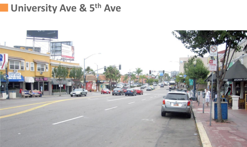
But the future looks bright for University Avenue
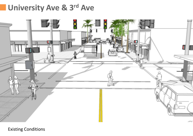
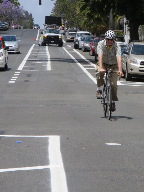
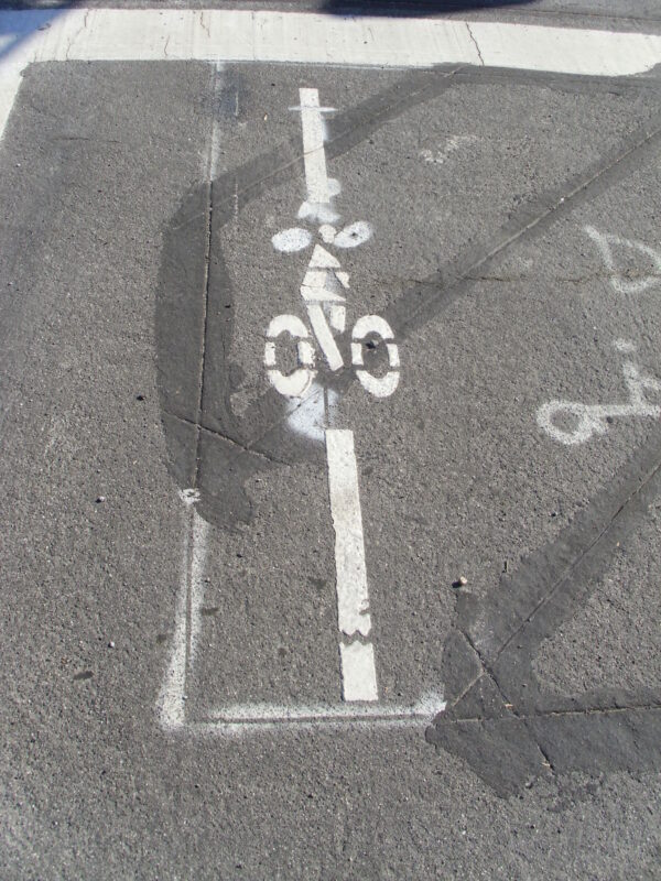
Today, University Avenue at 3rd is in a sorry condition. The best offering are some shared lane markings or sharrows along on University Avenue.
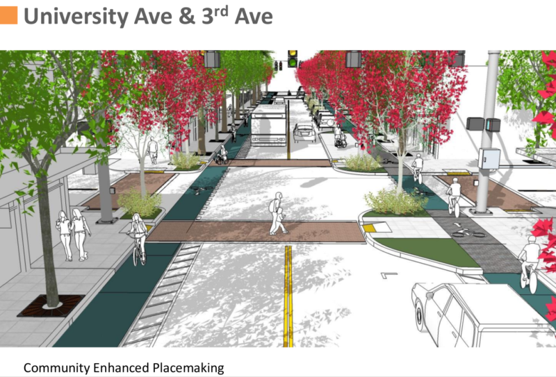
But the future looks very bright for University Avenue at 3rd with a proper protected bike lane/cycletrack.
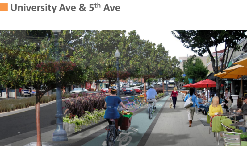
One of the north/south alignments is 5th Avenue. Last month the city's first road diets were implemented to much fanfare and publicity.
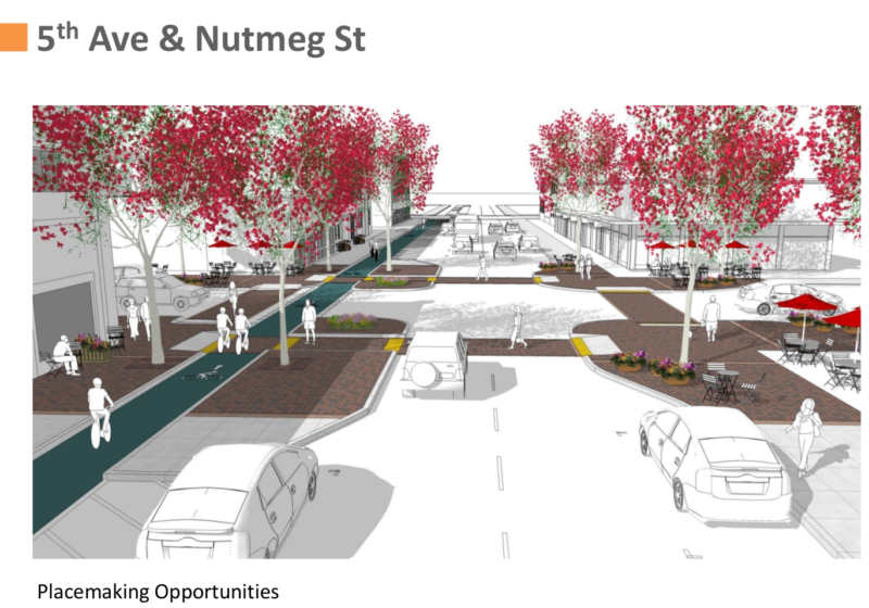
The future of 5th Avenue looks even better with, you guessed it, cycletracks:
One of our readers, Bonnie Kucera, sent in this video of great intersection design that fits right into what we've been advocating all this time.
The future does indeed look bright. Don't you wish it would get here quickly?
Foto Friday: Kensington Community Church Encourages Biking to Church
Last month was Bike Month, and one Friday was devoted to encouraging people to bike to work. But people travel by bicycle to places besides work. At least one local church, Kensington Community Church, is encouraging San Diegans to bike to church as evidenced by the prominent placement of three bike racks in front of the church.
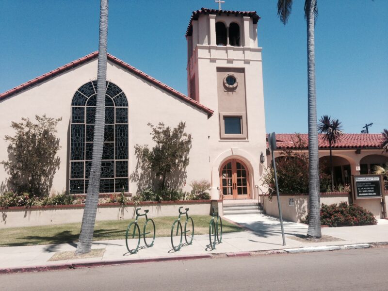
Kensington Community Church's Pastor, Darryl Kistler, has demonstrated his support for bicycling and has been discussing improving and expanding transportation access, especially for bicycling, for at least a year now. This is the sort of good leadership that all San Diegans need to bear witness to.
If you want to request a bike rack to be placed in front of your favorite venue, don't hesitate to contact the city.
Foto Friday: Bike Lane Detection Loops
I am, personally, opposed to guerrilla bike facilities. Do it yourself bike paths could lead to a horror show of mismatched cold patch asphalt atop a bed of gravel intermittently transitioning to easily washed-out sand. Inaccurately planned recreational mountain bike paths are a frequent target of the ire of those opposed to erosion. Even when sober traffic engineers governed by the California Manual of Uniform Traffic Control Devices (CAMUTCD) create signs, there's a bewildering variety of the same message. As far as I know, only the small city of Santa Clara, CA has had the vision to put the officially approved notice that wrong way bike traffic is riding in the wrong direction on the reverse side of their bike lane signs.
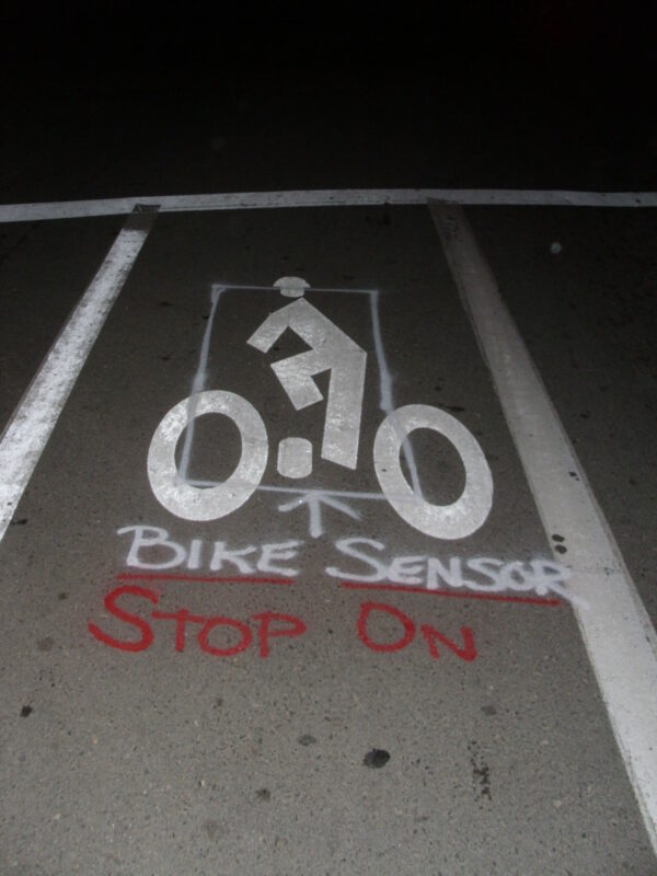
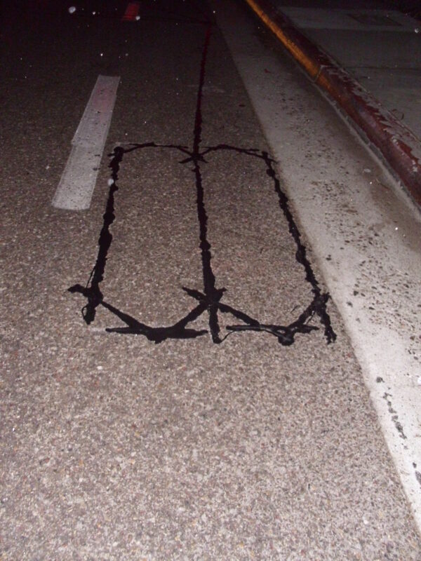
That said, I do sympathize with folks who get out the paint cans, spray chalk, shovels, stencils, tampers, and other tools and materials when confronted with a consistently irritating situation. The picture above is one example. It's a picture of Pacific Highway northbound at the intersection with Sea World Drive, just before it becomes Mission Bay Drive. Yes, fellow San Diego cyclists, there is an induction coil under that smooth pavement, ready and able to detect the magnetic fields induced by a bicycle and relay that signal to the controller for the traffic lights at that intersection. It's right under that bike lane bike rider stencil, but it's finicky. I've gotten my best results by stopping with the front wheel right atop the helmet! However, without that sort of local knowledge, how could anyone riding a bike know there's a detector down there, or how to get it to work? No wonder some frustrated rider, probably tired of coaching others, painted the white box and the red and white words giving precise, easy to follow instructions.
It's a shame someone had to go reinvent the wheel, or in this case the bike detection loop marking, as there is an official (yes, it's in the CAMUTCD) stencil pattern for precisely that message. The above example is from San Jose, CA. It features a smaller than normal cycling person image along a registration line that shows the “sweet spot” for being detected. It's equally applicable for detection loops designed with bicycles in mind and those regular traffic lane loops set to detect bike riders and their faithful non-motorized steeds.
That's in San Jose.
The City of San Diego, where it has detection loops in bike lanes or on other bike facilities, tends to not tag or label them at all. The example above, ineptly placed within a merge section of a bike lane on Regents Road southbound near La Jolla Village Drive, is typical. The casual viewer can see the hot melt seams where the detector loop was sealed underneath the surface, but there's no indication of what was done or why that would be apparent to a casual observer or someone not a connoisseur of paving and traffic control devices. It's a shame.
Foto Friday: A Floating Roundabout for Bicycles
 A Floating Cycle Roundabout. Photo by Bici Chic
Here is a video about the roundabout:
This roundabout is located in the Dutch city of Eindhoven (population 220,000). Here's why the roundabout was constructed:
Every day 25,000 vehicles pass this junction. The city wanted to emphasize this importance. Eindhoven is considered a brain port and feels it has a leading role in innovation and technology. All those qualities had to be reflected in the high quality design for this new piece of infrastructure: “spectacular in simplicity”.
This would look pretty nice over the on and off ramps at Balboa Avenue, don't you think?
Foto Friday: How do you envision your street?
Nothing gets 100 percent support in any city. You’re not looking for unanimous approval, otherwise you wouldn’t build a thing—8.4 million New Yorkers, 8.4 million points of view, and everybody considers himself a traffic engineer.
Now that San Diego is turning the page from an auto-centric focus to one that prioritizes people, it is gratifying to witness more and more people getting involved in their own communities by participating civically and then demanding street design that allocates space for bicycle riders. These baby steps are leading some into leadership positions within their own community:
The #CCPG has spoken: they love bikes. They have elected me to Chair the Transportation Committee. Cue Mr Burns voice... excellent.
— Michael Muhammad (@mbsully7) August 21, 2013
The folks at Code for America who utilize their software talents to build tools to engage residents to participate in their civic duty recently updated their phenomenal Streetmix tool to make redesigning streets way more fun and exciting. What is Streetmix? Streetmix allows you to
[d]esign, remix, and share your street. Add bike paths, widen sidewalks or traffic lanes, learn how all of this can impact your community.
Want a cycle track on your street? You can design it. How about a canopy of trees above you as you ride on that cycle track? Done!
So why not redesign your own street? Send those ideas in to us, your council representative and of course - your friendly city employees at the Transportation Department. Let them know what you'd like to see.