
A Nightmare in San Diego: The I-805 Project
The 2050 Regional Transportation Plan is supposed to be a vision for San Diego’s future. The introduction of the RTP has gems like this:
The 2050 Regional Transportation Plan (RTP or the Plan) is the blueprint for a regional transportation system that further enhances our quality of life, promotes sustainability, and offers more mobility options for people and goods.
And this:
The Plan envisions most of these new jobs and homes situated in environmentally sustainable communities that are more conducive to walking and bicycling. They also will have more access to public transit.
Yet, the entire basis of the plan’s implementation is based on improving (vehicular) Level of Service which is painfully evident if you review how the region is expected to look after the RTP’s implementation in 2050 (pink arrows are my markings noting where funds will be expended to alleviate vehicle congestion). To recap, Level of Service measures vehicular delay at intersections.

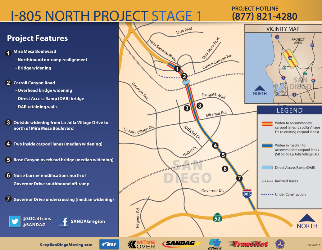
One of the projects listed in the 2050 RTP is the I-805 project and we’re going to take a good look at the northern section of this project: all 11 miles of it that is expected to cost $587 million. That is a cost of $53.36 million dollars per mile. This cost includes design and construction of the project (but not maintenance).
But what is the project going to deliver?
The project will widen the freeway to accommodate four carpool, or High Occupancy Vehicle (HOV), lanes from SR 52 to La Jolla Village Drive and two carpool lanes from La Jolla Village Drive to just north of Mira Mesa Boulevard.
Additionally, the project will construct Direct Access Ramps (DAR) at Nobel Drive and Carroll Canyon Road to allow commuters to easily access the carpool lanes.
At the southwest corner of I-805 and Nobel Drive, a Park & Ride lot will be constructed to encourage carpooling and to provide bus transfers from the proposed Bus Rapid Transit facility.
The project also reconfigures the Governor Drive interchange by relocating the southbound entrance-ramp to the northwest quadrant. This would minimize the conflict with southbound I-805 traffic getting on SR 52. Lastly, the project includes a direct freeway-to-freeway HOV connector in the median, from westbound SR 52 to northbound I-805 and southbound I-805 to eastbound SR 52.
Notice that the description makes no mention of how someone on foot or on bicycle is expected to navigate around this new monstrosity. As part of the environmental review process, the project considered three alternatives:
2. Transportation System Management (TSM) and Transportation Demand Management (TDM) Alternatives, or another way to say, “accommodating drivers and driving”.
3. No build alternative, which was immediately dismissed because “it would be inconsistent with the purpose and need of this project”
And what is the purpose of this project?
The overall purpose of this project is to provide a backbone of multi-modal transportation facilities for the I-805 North project area while providing safe and efficient regional movement of people and goods through design year 2030.
Or to put it another way, “multi-modal” meaning absolutely the opposite of that.
SANDAG unveiled a video seven months ago to offer an explanation of sorts on what the I-805 North Project was about, as explained by Gustavo Dallarda, Caltrans I-805/I-15/SR78 Corridor Director:
In short, Dallarda doesn’t understand the fundamentals of how to ease congestion. SANDAG who is funding the project simply assumes that the only way to solve San Diego’s traffic congestion woes is to widen roads and build additional lanes instead of providing sustainable or environmentally proven and sound transportation options. Despite Dallarda’s half nod to the project facilitating other modes of transportation besides the automobile – such as the Bus Rapid Transit that is scheduled to be built well after the automobiles have been accommodated – the project falls far short of any of the ideals described in the SANDAG RTP. And with the addition of even wider ramps that someone on a bicycle will have to navigate past speeding vehicles, what we’re looking at is the creation of a San Diego neighborhood that is going to be extremely unpleasant to be in.
In other words, SANDAG is funding a project that is contrary to the trends in this country.
What would it take for SANDAG to learn that roads cause congestion, and that the building of more roads is only going to exacerbate the problem?
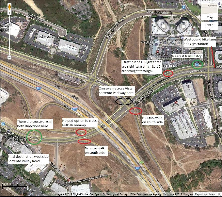
The I-805 North Project doesn’t go into the detail of how unbelievably unfriendly the project currently is to experience on a human level, and how much worse it is going to be.
The construction of the project has been going on for a little over a year now and the construction has made the situation in Mira Mesa awful, as narrated by Elaine Litchfield in the videos below:
The I-805 North Project lists among its features all the widening that is going to take place.
Litchfield and her husband live in Mira Mesa because she likes the neighborhood and her husband is able to take a BRT to his downtown job from a bus stop in front of their home. Her job is close enough that she can bike or walk to it – if it wasn’t so terrifying.
When SANDAG began the visioning process for the RTP, the narrator explained that, “for the first time our planning efforts must focus on how to reduce greenhouse gas emissions.”
Did SANDAG and the project’s lead agency, Caltrans, really evaluate all options prior to deciding to go through with this project? How is expanding the road capacity for a 11 mile stretch to the tune of $587 million going to alleviate traffic congestion along the entire corridor? How is building this project going to make the community a place that residents will want to live in? Who is going to pay for the maintenance of this project and how will those funds be raised? And most importantly, how is this project sustainable or even vaguely environmentally friendly?
To provide perspective on how better these funds could have been spent, the city of Denver unveiled a 12.1 mile light rail line last April that was built using sales tax revenue and cost $707 million dollars.
Wouldn’t a light rail be a better way to spend that $587 million to alleviate traffic congestion in San Diego?