
30th Street Bikeway Update – We Have a Real Opportunity
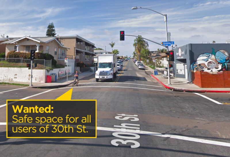
There’s a real opportunity for a transformative redesign of one of San Diego’s premiere urban streets — if we remind the city of its Complete Streets, Vision Zero and Climate Action Plan policies.
Just last week, the city started community outreach to gauge support for adding bike lanes to 30th Street from Juniper Street north to Howard Street following the pipeline replacement project. Councilmember Chris Ward’s office held the first of three meetings to solicit community input. After a preliminary study, city engineers concluded that two design options were feasible. The first option would add “Class II” bike lanes either against the curb south of Upas or between parked cars and the automobile traffic north of Upas. The second option would add protected bike lanes for the entire segment — called a “cycletrack,” the safest kind of on-street bike path.
[ UPDATE: April 4, 2019 – KPBS covers the story: https://www.kpbs.org/news/2019/apr/04/activists-rallying-protected-bike-lanes-north-park/ ]
Preserving parking spaces?
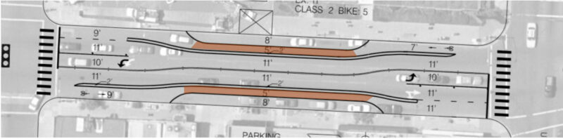
Unfortunately, city staff prepared a preliminary design based only on the first of these two options (drawings for northern section and for southern section). As explained by city staff, the preliminary striping plan was created to strike a compromise between the current bikeway-lacking roadway design and the need to preserve as much street parking as possible. Rather than a protected bikeway, the city’s design removes a small number of parking spaces but still makes bicyclists and scooter users ride between the automobile traffic and parked cars, exposing riders to the dangers of being “doored” (i.e., colliding with a car door) and getting thrown into traffic.
This is the similar minimal design that led to a cyclist’s death last week in San Francisco and prompted a quick fix to upgrade to a protected bike lane by removing parking. As San Francisco’s transit agency acknowledged, the death was preventable if the better design had been originally implemented.
Sharrows?
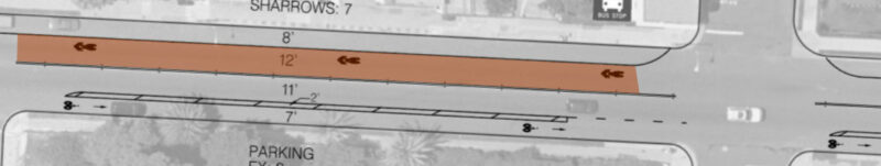
In the City’s proposed design for 30th Street, the section south of Upas is even less safe: bike lanes are placed only in some areas, and the city proposes using ‘sharrows’ — which require cyclists to share the lane with cars going between 25-35 miles per hour:
There are two main problems with the preliminary striping design. First, it contradicts the city’s own policies in North Park to design “complete streets” for all users. As defined in the community plan, a complete street is “designed for everyone in mind, for people of all ages and abilities using multiple modes of transit in lieu of car-oriented streets that are designed to primarily accommodate the automobile.” At the first community meeting, city staff admitted that the preliminary design was not an “8-80” facility, meaning one designed for users from the ages of 8 to 80.
CAP goals missed
Second, the preliminary design doesn’t go far enough to honor the city’s commitments to reach the binding targets of its Climate Action Plan (CAP): to reduce the number of car trips and increase the share of walking, biking, and non-car trips in the city.
The CAP goals shaped the debate about the North Park Community Plan, one of the first community plan updates passed after the CAP. When the update was being crafted in 2016, an analysis by the city showed that the proposed street design in the adopted plan was not enough, standing alone, for the city to achieve its CAP goals.
The City reassured the city council and community that it could meet the CAP goals because the community plan “does not account for other programs and policies that would be implemented throughout the life of the community plans, such as additional bicycle and pedestrian improvements whenever street resurfacing occurs, as feasible.” To make sure these “additional” policies weren’t empty promises, the city expressly included a commitment in the community plan to planning additional bike lanes in coordination with street resurfacing.
To achieve these goals, the city council later directed staff to “leverage coordination of street resurfacing to take advantage of opportunities for progressive design standards to facilitate safer mobility, including… protected bikeways.”
The time has now come for the city to honor its commitments to fighting climate change and following through on its Climate Action Plan goals and Vision Zero policy by designing a street that serves all users and does not primarily cater to motorists. As specified in the City’s own policies, any restriping plan should follow progressive design standards to add a protected bikeway “designed for everyone in mind, for people of all ages and abilities using multiple modes of transit in lieu of auto-oriented streets that are designed to primarily accommodate the automobile.” A progressive bikeway design will also make it easier for pedestrians to cross the street by shortening the width of the roads devoted to speeding cars.
Safer lanes can reduce parking needs
Designing a safe 30th Street for pedestrians and cyclists doesn’t have to unreasonably impair parking. For the commercial district north of Upas, there are nearly 1,400 public parking spaces either on the street or in the parking garage within one block of 30th Street. The city could maintain over 90 percent of that parking and add protected bike lanes and pedestrian improvements. If cycling increases on 30th Street in the same way it has in other cities that added protected bike lanes, the number of new daily cyclists would likely exceed the number of lost parking spaces.
The City has adopted one set of progressive design standards, set forth in the NACTO Urban Bikeway Design Guide that directly address how to design a bike facility for all age and abilities. Given the speed of cars, the level of traffic, and the presence of a city bus line, the only option that fulfills the City’s policies is a protected cycletrack design. The city already identified such a design as being feasible on 30th Street. The City needs to present this second option for its next community review and not be limited to only the “less safe” first option shown at the first meeting.
It will take a collective effort to make sure the City of San Diego honors its climate and Vision Zero safety commitments. We need to make sure the City doesn’t commit to a less safe street design because of speculative fear that a loss of parking will lead to failing businesses. It turns out the bike lanes help business: Study after study after study after study after study shows that cyclists spend more in shops than drivers. These studies show that removing street parking to add bike lanes often results in substantial increases in sales in nearby shops or, at worst, no significant negative effects.
We need your help
Yes! I support bike lanes on 30th St. I’ll sign the petition.There are three easy steps everyone can take to help us achieve something transformative in North Park:
- Sign the petition asking Mayor Faulconer to honor the city’s promises by directing staff to design a high-class protected bikeway on 30th Street.
- Let the City see the community that wants safer streets for everyone by posting a photo of you, friends and family using the hashtag #SafeLanesOn30th and be sure to tag @BikeSD.
- Last but perhaps most importantly, attend the community outreach meeting at the North Park Planning Committee on April 16th at 6:30pm at 2901 North Park Way (2nd Floor). Showing broad community support at this meeting will be critical!