
30th Street Bikeway Update - We Have a Real Opportunity

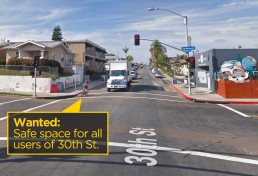
There’s a real opportunity for a transformative redesign of one of San Diego’s premiere urban streets — if we remind the city of its Complete Streets, Vision Zero and Climate Action Plan policies.
Just last week, the city started community outreach to gauge support for adding bike lanes to 30th Street from Juniper Street north to Howard Street following the pipeline replacement project. Councilmember Chris Ward’s office held the first of three meetings to solicit community input. After a preliminary study, city engineers concluded that two design options were feasible. The first option would add “Class II” bike lanes either against the curb south of Upas or between parked cars and the automobile traffic north of Upas. The second option would add protected bike lanes for the entire segment — called a “cycletrack,” the safest kind of on-street bike path.
[ UPDATE: April 4, 2019 - KPBS covers the story: https://www.kpbs.org/news/2019/apr/04/activists-rallying-protected-bike-lanes-north-park/ ]
Preserving parking spaces?
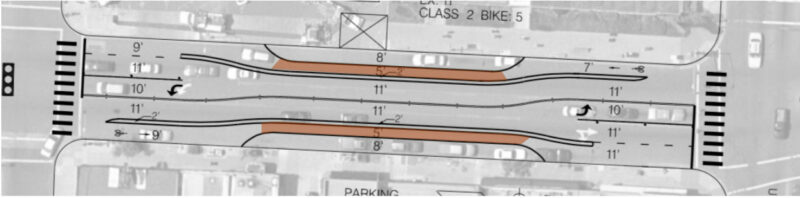
Unfortunately, city staff prepared a preliminary design based only on the first of these two options (drawings for northern section and for southern section). As explained by city staff, the preliminary striping plan was created to strike a compromise between the current bikeway-lacking roadway design and the need to preserve as much street parking as possible. Rather than a protected bikeway, the city’s design removes a small number of parking spaces but still makes bicyclists and scooter users ride between the automobile traffic and parked cars, exposing riders to the dangers of being “doored” (i.e., colliding with a car door) and getting thrown into traffic.
This is the similar minimal design that led to a cyclist’s death last week in San Francisco and prompted a quick fix to upgrade to a protected bike lane by removing parking. As San Francisco’s transit agency acknowledged, the death was preventable if the better design had been originally implemented.
Sharrows?
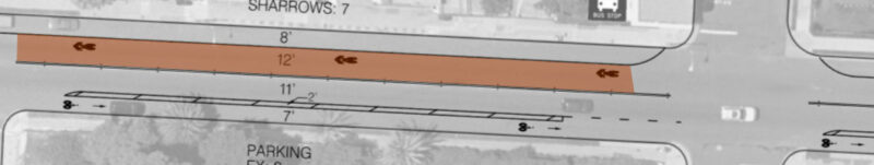
In the City’s proposed design for 30th Street, the section south of Upas is even less safe: bike lanes are placed only in some areas, and the city proposes using ‘sharrows’ — which require cyclists to share the lane with cars going between 25-35 miles per hour:
There are two main problems with the preliminary striping design. First, it contradicts the city’s own policies in North Park to design “complete streets” for all users. As defined in the community plan, a complete street is “designed for everyone in mind, for people of all ages and abilities using multiple modes of transit in lieu of car-oriented streets that are designed to primarily accommodate the automobile.” At the first community meeting, city staff admitted that the preliminary design was not an “8-80” facility, meaning one designed for users from the ages of 8 to 80.
CAP goals missed
Second, the preliminary design doesn’t go far enough to honor the city’s commitments to reach the binding targets of its Climate Action Plan (CAP): to reduce the number of car trips and increase the share of walking, biking, and non-car trips in the city.
The CAP goals shaped the debate about the North Park Community Plan, one of the first community plan updates passed after the CAP. When the update was being crafted in 2016, an analysis by the city showed that the proposed street design in the adopted plan was not enough, standing alone, for the city to achieve its CAP goals.
The City reassured the city council and community that it could meet the CAP goals because the community plan “does not account for other programs and policies that would be implemented throughout the life of the community plans, such as additional bicycle and pedestrian improvements whenever street resurfacing occurs, as feasible.” To make sure these “additional” policies weren’t empty promises, the city expressly included a commitment in the community plan to planning additional bike lanes in coordination with street resurfacing.
To achieve these goals, the city council later directed staff to “leverage coordination of street resurfacing to take advantage of opportunities for progressive design standards to facilitate safer mobility, including... protected bikeways.”
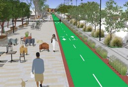
The time has now come for the city to honor its commitments to fighting climate change and following through on its Climate Action Plan goals and Vision Zero policy by designing a street that serves all users and does not primarily cater to motorists. As specified in the City’s own policies, any restriping plan should follow progressive design standards to add a protected bikeway “designed for everyone in mind, for people of all ages and abilities using multiple modes of transit in lieu of auto-oriented streets that are designed to primarily accommodate the automobile.” A progressive bikeway design will also make it easier for pedestrians to cross the street by shortening the width of the roads devoted to speeding cars.
Safer lanes can reduce parking needs
Designing a safe 30th Street for pedestrians and cyclists doesn’t have to unreasonably impair parking. For the commercial district north of Upas, there are nearly 1,400 public parking spaces either on the street or in the parking garage within one block of 30th Street. The city could maintain over 90 percent of that parking and add protected bike lanes and pedestrian improvements. If cycling increases on 30th Street in the same way it has in other cities that added protected bike lanes, the number of new daily cyclists would likely exceed the number of lost parking spaces.
The City has adopted one set of progressive design standards, set forth in the NACTO Urban Bikeway Design Guide that directly address how to design a bike facility for all age and abilities. Given the speed of cars, the level of traffic, and the presence of a city bus line, the only option that fulfills the City’s policies is a protected cycletrack design. The city already identified such a design as being feasible on 30th Street. The City needs to present this second option for its next community review and not be limited to only the “less safe” first option shown at the first meeting.
It will take a collective effort to make sure the City of San Diego honors its climate and Vision Zero safety commitments. We need to make sure the City doesn’t commit to a less safe street design because of speculative fear that a loss of parking will lead to failing businesses. It turns out the bike lanes help business: Study after study after study after study after study shows that cyclists spend more in shops than drivers. These studies show that removing street parking to add bike lanes often results in substantial increases in sales in nearby shops or, at worst, no significant negative effects.
We need your help
Yes! I support bike lanes on 30th St. I'll sign the petition.There are three easy steps everyone can take to help us achieve something transformative in North Park:
- Sign the petition asking Mayor Faulconer to honor the city’s promises by directing staff to design a high-class protected bikeway on 30th Street.
- Let the City see the community that wants safer streets for everyone by posting a photo of you, friends and family using the hashtag #SafeLanesOn30th and be sure to tag @BikeSD.
- Last but perhaps most importantly, attend the community outreach meeting at the North Park Planning Committee on April 16th at 6:30pm at 2901 North Park Way (2nd Floor). Showing broad community support at this meeting will be critical!
Normal Street Promenade Workshop - Thursday, January 24, 6:00 PM

The Normal Street Promenade will be a new public space in Hillcrest along Normal Street between University Avenue and Washington Street and will be the first transit-oriented pedestrian promenade in San Diego.
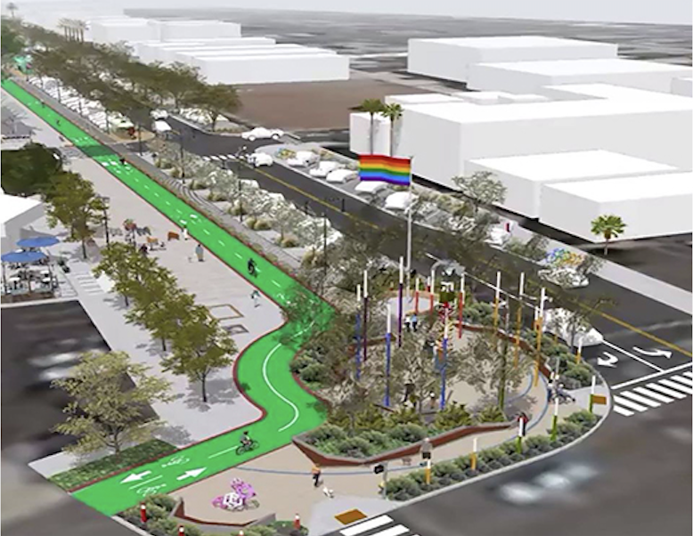 To develop the final concept, the City of San Diego and SANDAG will work with the community through a series of workshops. The conference room at Joyce Beers Community Hall will have different stations showing the bare bones concept and then a visual preference station showing options for lighting, landscaping, etc.
The first workshop will be held:
DATE: Thursday, January 24th
TIME: 6:00-9:00 p.m.
LOCATION: Joyce Beers Hall, 3900 Vermont St, San Diego
Please be sure to join fellow residents and learn more about this upcoming project. More background on our earlier report on the Normal Street Promenade here.
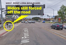
West Point Loma Blvd bike lanes: still no approval from PCPB
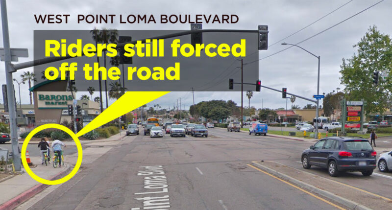
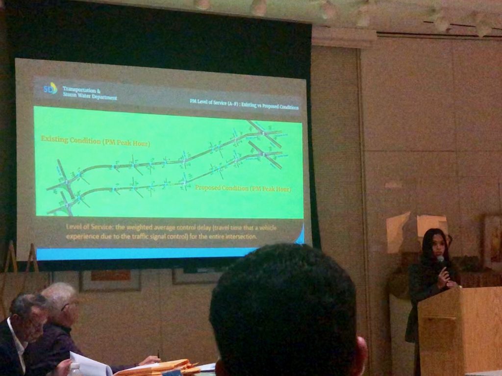
On Thursday night, staff from San Diego's Traffic & Storm Water Division (TSW) presented slides detailing the West Point Loma Blvd bike lane project to the Peninsula Community Planning Board (PCPB). The project encompasses a "road diet" on a 4-lane-wide stretch of West Point Loma Blvd., reconfigured to a 2-car-lane street with a Class 2 bike lane (paint-buffered only) and other traffic calming measures. This was the third presentation since October 2018 made by the city to the Peninsula community board about the West Point Loma Blvd. bike lane project. TSW's slideshow gave PCPB the results of their detailed traffic analysis, parking study data, lane configuration drawings, and Level of Service (LoS) impacts — all of which showed minimal impacts on drivers along the corridor — in an effort to win approval from the community board for the project.
Unfortunately, the PCPB did not approve the project, though it also did not make a motion of denial.
 Speakers in support of the project from BikeSD and San Diego County Bicycle Coalition urged the board to approve the bike facility. There were also others, including local residents on West Point Loma Blvd, that also spoke in favor of better bicycle facilities along this corridor.
There were also a handful of residents that were opposed or had questions. Two audience members took issue with the term "road diet," and insisted that this should be called a "lane removal." Board members' questions focused on issues of traffic delay, the 'back-in/angled parking' configuration, the decline from a Grade B to a Grade C 'Level of Service', and the 'math not working out' when a car lane was removed. These questions were challenging for TSW staff, who gave technical answers that didn't mollify critics on the board.
Many of the PCPB board members shared desire for better bicycle facilities but still wanted to critically discuss specific design elements. Nicole Burgess of BikeSD said, "I think some them truly want to be traffic engineers."
In the end, there was no vote on the project but the board passed a motion calling for the City to return and discuss it further at the PCPB Transportation Subcommittee.
 Nicole Burgess wrote San Diego Mayor Kevin Faulconer immediately following the meeting, "I believe the City has done due diligence and provided adequate information as they have presented three times now at the PCPB. Also, as a reminder, the OB Planning Group unanimously supported a road diet to provide safe bicycle facilities."
BikeSD believes that Level of Service (LoS) should not be the focus of presentations about bike infrastructure, just as it has been removed as a valid topic for CEQA studies. LoS leads to a very narrow discussion about the impact on drivers and travel-time rather than safety and the equitable use of public rights-of-way. Instead, the Vision Zero Systematic Solutions for Safety should be the leading guideline for these types of improvements. We can not let Community Planning Groups make final decisions for the safety measures needed for our streets to meet Vision Zero and CAP goals.
The West Point Loma bike facility was originally proposed by the Bicycle Advisory Board back in the spring of 2018, with unanimous support for the project. For the safety of all road users, BikeSD is hopeful that Mayor Faulconer and Councilmember Jennifer Campbell will advocate for this type of improvement in their community. We applaud TSW's proposed striping plans and believe this Class 2 bike lane is an essential piece of the puzzle to fill in the gap along this corridor.
Yes! I support BikeSD's advocacy for safety. Tell me about becoming a member...
(Plus, receive a free BikeSD t-shirt with every membership, while supplies last.)
The Downtown Mobility Plan hits the ground but much work remains

 The Downtown Mobility Plan (DMP) has broken ground in San Diego as of December 19, 2018! Paint crews began striping thermoplastic lanes along J Street and the entire DMP Phase 1 should be complete “in a few months time,” according to Mayor Faulconer. This day has been a long time coming after years of planning, delays and cost overruns, but we’d like to offer our thanks to Mayor Faulconer for pushing this project forward over the last couple of months. We note that in 2016 the mayor pledged to complete all cycletracks during his 2nd term.
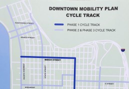
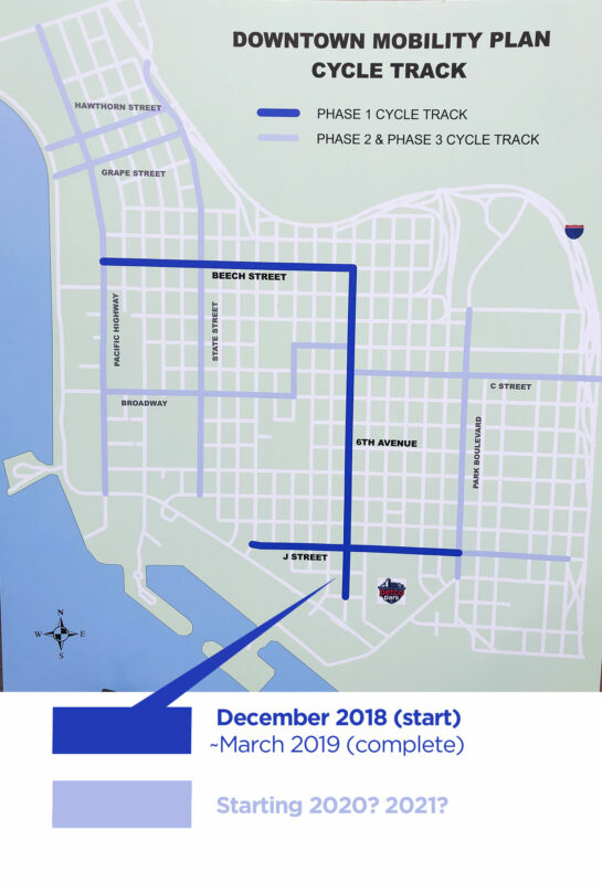
The Downtown Mobility Plan’s first phase will create Class VI bike tracks on:
- Beech Street from Pacific Highway to Sixth Avenue
- Sixth Avenue from Beech Street to Harbor Drive
- J Street from 1st Avenue to Park Boulevard
These tracks are two-way cycle tracks (special bike lanes that provide a right-of-way for cyclists and scooter riders within the roadway). Parked cars, flex posts, and or grade variations will separate the tracks from vehicular traffic. When all three phases are fully built-out, the Downtown Mobility Plan will provide 9.3 miles of these two-way cycle tracks around downtown San Diego, connecting points like the Convention Center with Balboa Park.

R-L: CM Chris Ward, Mayor Faulconer, SDCBC's Andy Harkan, BikeSD's Nicole Burgess, and Randy Torres-Van Vleck at the press conference announcing the start of the Downtown Mobility Plan bikeway. - Dec 21, 2018
BikeSD was there at the start of discussions for the Downtown Mobility Plan, we were there in April of this year when the mayor’s office wanted to change the design and delay this project an additional 5 years, and we were there for today’s press conference as well. We applaud the mayor for getting this often-delayed project out of the City’s Streets Division and onto city streets.
While Phase 1 is a great start, Phases 2 and 3 represent the greater share of the Downtown Mobility Plan bikeways and will likely not unfold as quickly or easily as Phase 1. Natalia Torres, Associate Civil Engineer for the City’s Streets Division, explained that the later Downtown phases may not be managed by the City’s Streets Division but instead may be handled by the Department of Public Works (DPW). For those not familiar with the city’s bifurcated engineering divisions, this could be bad news for cyclists and scooter users because DPW is often slower to roll out infrastructure. DPW staff typically handle physical infrastructure like drains, underground wiring, and things like Americans with Disability Compliance elements. DPW often takes longer because they deal less often with things like bikeway design and surface configuration. And given that later phases of the Plan involved difficult pedestrian and bike connections to the notoriously bad Pacific Coast Highway, this challenge will be significant for DPW staff to handle.
BikeSD and other mobility advocates will need to continue to press the city to move forward on the DMP, especially to push the city to use the Streets Division to implement Phase 2 and 3 of the plan so that it doesn’t get slowed down. And we expect continued opposition from groups like the Little Italy Association, which has a history of opposing bike lanes in their district.
Even though today was a day to celebrate a small victory for biking, scooting, and walking safety, there’s a long road ahead to complete the full vision of the Downtown Mobility Plan. The news media will move on from this story. Elected officials may change or depart. Engineering staff may move on to other projects. But BikeSD will be there, making sure that the Downtown Mobility Plan continues to get attention and move towards full completion.
Yes! I support BikeSD. Tell me about becoming a member...
(Plus, receive a free BikeSD t-shirt with every membership, while supplies last.)

Little hope for MidCoast and Balboa Transit Station
 The City of San Diego's Balboa Specific Plan is going to the San Diego Planning Commission tomorrow at 9:00 AM, Thursday, December 13, at Council Chambers, 12th Floor, City Administration Bldg., 202 C Street, San Diego CA 92101. It will then be heard at City Council next month.
BikeSD does not support The Balboa Specific Plan (full plan PDF is found here) because it lacks any vision for an ecologically-friendly gateway into the Pacific Beach community. BikeSD does support the diverse community members who are advocating for a better plan that does not aim towards a car-centric future for this station or this community.
This area of San Diego is receiving a $2.2 billion dollar investment as one of the nation’s thirteen 'EcoDistrict Communities' yet the City fails to support this vision in its design of Balboa Transit Station's with limited access from across Interstate 5 from the west, Pacific Beach.
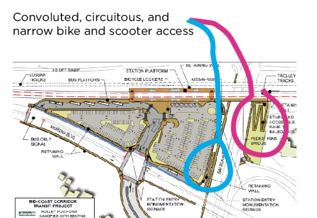
Any transit station is only successful if it addresses the last mile connection between where residents live and the transit services they're ultimately seek to use. Despite a gap between Mid-Coast and Bay that is less than a mile, the Balboa Specific Plan presents no real solution for getting active commuters safely across the I-5 freeway. This will severely lower the use of this new station.
The new station design accommodates car and truck access well, with ample parking lots. But for transit riders who approach the station on foot, by bike, wheelchair, or micro-mobility devices, all that's provided is a 4-foot wide path across Balboa Avenue. To be successful, this station needs a bigger, first-class multi-use path.
Making matters worse, the small bridge provided in the Plan leads riders and walkers into the mess of a vehicle-congested intersection at Garnet Ave. and Mission Bay Drive. This is substandard, terrible planning.
BikeSD says it's time to listen to the residents. They are asking for a multi-use bridge over the I-5 to safely connect all transit users to their homes, to the beach, to Mission Bay, and to the businesses in Pacific Beach. They're asking for a design that lets these residents enjoy their last mile along the waterfront, visiting a local coffee shop, or just getting some fresh air before their next task in life.
We need the proposed bridge (or tunnel) across the I-5 to be in the plan and to be prioritized. It can be done and should be done ASAP. The plan should also include Class IV bike lanes on Garnet Ave. and Mission Bay Drive, dedicated bike signalization, and protected intersections.
This station will open and soon and it is exciting for our region to have a beautiful new transit line, but if we cannot accommodate these eco-friendly commuters, then we have failed in the process.
And it's also critical that MTS be part of this discussion. Large buses into and out of Pacific Beach is not the answer - innovative small autonomous shuttles will support this movement in a better way and I hope SANDAG and MTS can pilot such a program.
BikeSD urges biking, walking, and scooting advocates to go to the Planning Commission and speak for adding better mult-use access to the new station, especially from the western (Pacific Beach) approach.